Nearly 11 million people in the heart of Texas, including Austin, Fort Worth and Dallas, face an enhanced threat of severe thunderstorms on Tuesday, the US Storm Prediction Center said. The systems bring the “potential for significant damaging wind and area of very large hail,” according to forecasters Andy Dean and Andrew Moore.
The threat comes after violent storms ripped through the Midwest and South during the Memorial Day holiday weekend, killing at least 22, according to the Associated Press. Across the US, 186,077 customers are without power from West Virginia to Texas, according to PowerOutage.us, with the most in Kentucky.
Severe thunderstorms warnings and watches were posted across parts of Oklahoma and the Dallas-Fort Worth area in Texas at 5:30 a.m. New York time, the National Weather Service said. In addition to the storms, high temperatures and humidity will sear down across southern Texas pushing heat index values as high as 110F (43C).
Across the border, Mexico has been sweltering under extreme temperatures for weeks, as the country’s citizens prepare to elect a new president on June 2.
It’s capital city posted new heat records for May 17 and 26, with highs into the 90sF and overnight lows in the 60s, said Paul Pastelok, a meteorologist with commercial forecaster AccuWeather Inc. Normally at this time of year Mexico City would have highs in the 70s and overnight lows in the 50s, he said.
Only one night all month has dropped into the 50s. “That is impressive,” Pastelok said. The city tied existing heat records on May 23, 24 and 25.
Mexico has been plagued with not only heat, but also drought, which will continue for at least a few more weeks, he said. The annual monsoon that usually starts in southwestern Mexico in May has been non-existent this year, which has added to the extreme conditions. There is a chance that tropical moisture coming in off the Caribbean and Gulf of Mexico will bring the country much needed rains and cool temperatures.
Across Mexico readings are forecast to run 3F to 5F (2C to 3C) degrees above normal through this week and get warmer the first week of June, according to Commodity Weather Group LLC.
In other weather news:
Tropic: Typhoon Ewiniar will continue to weaken as it moves northeast through the Pacific Ocean away from the Philippines, the US Joint Typhoon Warning Center said. It is forecast to sweep to the east of Japan in the next few days. There is a slight risk it could graze eastern Japan in coming days. The remnants of Cyclone Remal moved across northeast Bangladesh and Meghalaya, India Meteorological Department said. It will continue to weaken as it drifts northeast.
Sun: An X2.8 flare blew out of sunspot Region 3664 Sunday, which is coming back around on the Earth-facing side of the Sun. The flare caused an R3 radio blackout storm. This is the large complex that caused solar storms earlier in May that stressed electric grids and caused widespread auroral displays around the world. “This is now in the process of rotating onto the southeast limb and further flares remain likely,” the UK Met Office said in a statement. “There are eight other regions currently on the Earth-facing disc, however most are small and simple.”
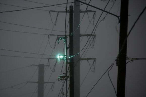
Top photo: A power line damaged by high winds sparks as Hurricane Delta makes landfall in Lake Charles, Louisiana, U.S., on Friday, Oct. 9, 2020. Delta slammed into the U.S. Gulf Coast with a deadly storm surge and violent winds, threatening to batter an area of Louisiana still recovering from Hurricane Laura.
Was this article valuable?
Here are more articles you may enjoy.
 Canceled FEMA Review Council Vote Leaves Flood Insurance Reforms in Limbo
  One out of 10 Cars Sold in Europe Is Now Made by a Chinese Brand
  China Bans Hidden Car Door Handles in World-First Safety Policy
  Hackers Hit Sensitive Targets in 37 Nations in Spying Plot
Want to stay up to date?
Get the latest insurance news
sent straight to your inbox.