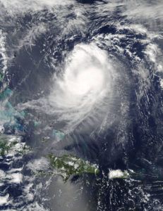
Don’t underestimate Jose. The meteorological gods seem to be working against the hurricane as Irma’s successor lumbers over the Atlantic Ocean. But it’s so far out – more than 960 miles from New York – that it’s too soon to call the all clear.
“If it is going to be a threat, it is probably a threat next week,” said Rob Carolan, a meteorologist at Hometown Forecast Services Inc. in Nashua, New Hampshire. For now, though, “Jose is having very serious issues.”

Credits: NASA Goddard MODIS Rapid Response Team
Hurricanes can’t move under their own power, and the high-pressure system directing Jose Wednesday was pushing and shoving it into making a loop around the central Atlantic, said Jeff Masters, co-founder of Weather Underground in Ann Arbor, Michigan. Carolan said that could have the benefit of robbing the cyclone of muscle as it circles back over its own wake, churning up the cold water that saps storms’ strength.
At the same time, the loop could easily turn Jose to point directly at North America, a maneuver that would put about $18.8 trillion in property from Maine to Florida in a potentially devastating shadow.
“That sort of behavior is difficult to model,” Masters said. “Especially when you don’t have an accurate picture of conditions.”
It may be days before the forecasting image becomes clearer, thanks in part to Irma, said Peter Sousounis, director of meteorology at AIR Worldwide, a risk modeler based in Boston. Irma threw out what are called Rossby Waves, which can stretch for thousands of miles. They joggled the upper atmosphere and messed with the steering currents around Jose.
Computer models have had Jose passing harmlessly out to sea – or crashing ashore anywhere from North Carolina to Nova Scotia.
The storm was swirling around the Atlantic about 435 miles (700 kilometers) south of Bermuda with top winds of 75 mph, as of 5 a.m. New York time. On its current track, high winds could be reaching the island late Friday as it passes north between there and the East Coast, the National Hurricane Center said.
There is a chance Jose will fall below hurricane strength in about three days as its top winds dip to 70 mph. Or it could end up in a patch of ocean that would allow it to draw in warm water and become more formidable.
Hurricane Hunters
The experts just don’t have enough data yet. While satellites can look down, the Atlantic isn’t dotted with weather stations that can send balloons 22 miles into the sky to sample conditions. And it’s those measurements that make the models accurate.
The U.S. often uses Air Force Reserve and National Oceanic and Atmospheric Administration pilots and crews, called Hurricane Hunters, to fly into storms and drop instruments and launch Coyote drones into the winds.
One of those hunters discovered that at its peak at 11 p.m. New York time on Sept. 8, Jose’s winds reached 155 miles per hour, making it a Category 4 storm and a near rival of Irma.
The 2017 Atlantic hurricane season has already claimed at least 100 lives and inflicted estimated damage of at least $135 billion from Texas and Florida to across the Caribbean. Harvey also temporarily shut about 25 percent of oil and natural gas production in the Gulf of Mexico and 10 percent of U.S. refining capacity. Irma subjected Florida’s citrus groves to fruit losses that are just now being tallied.
If Harvey and Irma offer any lesson, it’s that a storm like Jose needs to be taken seriously.
“It could very well intensify again,” Sousounis said. “We cannot turn our heads away from Jose.”
Was this article valuable?
Here are more articles you may enjoy.

 UBS Top Executives to Appear at Senate Hearing on Credit Suisse Nazi Accounts
  Tesla Sued Over Crash That Trapped, Killed Massachusetts Driver
  LA County Told to Pause $4B in Abuse Payouts as DA Probes Fraud Claims
  Cape Cod Faces Highest Snow Risk as New Coastal Storm Forms