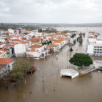
Tropical cyclone Ketsana made landfall on Northern Luzon in the Philippines on Saturday as a tropical storm with wind speeds of around 40 mph (64 kph). Although the velocity of the wind wasn’t strong enough to cause serious damage, “the combination of the storm with the active Southwest Monsoon resulted in very heavy and persistent rainfall across a large area that has triggered widespread and severe flooding in and around the Capital City of Manila,” said a report from Risk Management Solutions.
The heavy rainfall caused riverbanks to overflow, with the heaviest flooding in central Manila, where reports indicate that “as much as 80 percent of the city is submerged by flood waters at least 6 meters (20 feet) deep in some places, displacing over 400,000 residents from their homes,” said the bulletin.
“Rainfall accumulations of between 35-55 cm (13.78-21.65 inches) were recorded in a period of 6-12 hours in some locations which equates to amounts more typically seen over an entire month during the monsoon period,” RMS continued. “Rainfall accumulations exceeded 40 cm (15.75 inches) in Manila, which is more than the monthly average of 39 cm (15.35 inches) and is the highest amount recorded for over 40 years.”
The most recent news reports put the death toll at around 240 persons, with many people missing. The number of dead is expected to rise significantly as rescue workers continue the task of cleaning up after the floods.
Typhoon Ketsana is currently over South China Sea as a Category 1 storm. On its present forecast trajectory Ketsana would make landfall on the east coast of Vietnam “within the next 36 hours near to Da Nang, a major port city with a population of around 750,000. The city is the fourth largest in Vietnam and has many light industries based there including seafood export, furniture, household goods, clothing and tourism,” said RMS.
Source: Risk Management Solutions – www.rms.com
Was this article valuable?
Here are more articles you may enjoy.

 Portugal Rolls Out $2.9 Billion Aid as Deadly Flooding Spreads
  US Will Test Infant Formula to See If Botulism Is Wider Risk
  UBS Top Executives to Appear at Senate Hearing on Credit Suisse Nazi Accounts
  China Bans Hidden Car Door Handles in World-First Safety Policy