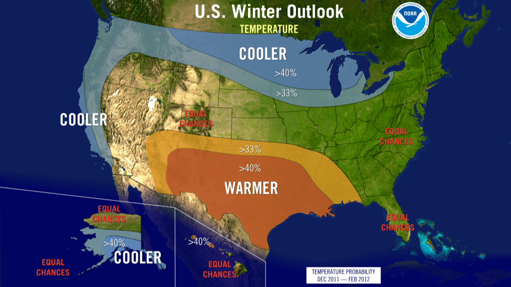
The Southern Plains should prepare for continued drier and warmer than average weather, while the Pacific Northwest is likely to be colder and wetter than average from December through February, according to the annual Winter Outlook released today by NOAA.
For the second winter in a row, La Niña will influence weather patterns across the country, but as usual, it’s not the only climate factor at play. The “wild card” is the lesser-known and less predictable Arctic Oscillation that could produce dramatic short-term swings in temperatures this winter.
NOAA expects La Niña, which returned in August, to gradually strengthen and continue through the upcoming winter. It is associated with cooler than normal water temperatures in the tropical Pacific Ocean and influences weather throughout the world.
“The evolving La Niña will shape this winter,” said Mike Halpert, deputy director of NOAA’s Climate Prediction Center. “There is a wild card, though. The erratic Arctic Oscillation can generate strong shifts in the climate patterns that could overwhelm or amplify La Niña’s typical impacts.”
The Arctic Oscillation is always present and fluctuates between positive and negative phases. The negative phase of the Arctic Oscillation pushes cold air into the U.S. from Canada. The Arctic Oscillation went strongly negative at times the last two winters, causing outbreaks of cold and snowy conditions in the U.S. such as the “Snowmaggedon” storm of 2009. Strong Arctic Oscillation episodes typically last a few weeks and are difficult to predict more than one to two weeks in advance.
With La Niña in place Texas, Oklahoma, New Mexico and parts of surrounding states are unlikely to get enough rain to alleviate the ongoing drought. Texas, the epicenter of the drought, experienced its driest 12-month period on record from October 2010 through September 2011. July was the hottest summer on record for Oklahoma and the hottest summer ever recorded for any state.
According to David Brown, NOAA’s southern regional climate services director, 2011 has been an extreme year in weather and climate conditions with 91 percent of Texas, 87 percent of Oklahoma, and 63 percent of New Mexico in extreme or exceptional drought status. Wildfires have burned more than 3.5 million acres in Texas and over 1 million acres in New Mexico.
Highlights of the U.S. Winter Outlook (December through February) include:
Pacific Northwest: colder and wetter than average. La Niña often results in below-average temperatures and increased mountain snow in the Pacific Northwest and western Montana during the winter months. This may set the stage for spring flooding in the Missouri River Basin;
California: colder than average with odds favoring wetter than average conditions in northern California and drier than average conditions in southern California. All of the southern part of the nation are at risk of having above normal wildfire conditions starting this winter and lasting into the spring;
Northern Plains: colder and wetter than average. Spring flooding could be a concern in parts of this region;
Southern Plains and Gulf Coast States: warmer and drier than average. This will likely exacerbate drought conditions in these regions;
Florida and south Atlantic Coast: drier than average, with an equal chance for above-, near-, or below-normal temperatures. Above normal wildfire conditions;
Ohio and Tennessee Valleys: wetter than average with equal chances for above-, near-, or below-average temperatures. Potential for increased storminess and flooding;
Northeast and Mid-Atlantic: equal chances for above-, near-, or below-normal temperatures and precipitation. Winter weather for these regions is often driven not by La Niña but by the Arctic Oscillation. If enough cold air and moisture are in place, areas north of the Ohio Valley and into the Northeast could see above-average snow;
Great Lakes: tilt toward colder and wetter than average;
Hawaii: Above-average temperatures are favored in the western islands with equal chances of above-, near-, or below average average precipitation. Statewide, the current drought is expected to continue through the winter. Drought recovery is more likely over the windward slopes of the BigIsland and Maui;
Alaska: colder than average over the southern half of the state and the panhandle with below average precipitation in the interior eastern part of the state.
Source: NOAA
Was this article valuable?
Here are more articles you may enjoy.

 Why 2026 Is The Tipping Point for The Evolving Role of AI in Law and Claims
  UBS Top Executives to Appear at Senate Hearing on Credit Suisse Nazi Accounts
  Credit Suisse Nazi Probe Reveals Fresh SS Ties, Senator Says
  US Will Test Infant Formula to See If Botulism Is Wider Risk