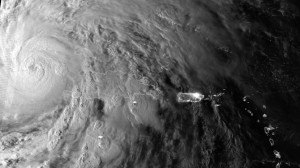
As Hurricane Sandy makes its way toward the eastern seaboard of the United States, disaster experts and meteorologists warn that the mid-Atlantic and Northeastern states face dangerous winds and heavy rains that could trigger flooding in the coming days.
Some forecasters even say that Sandy has the potential to be a multibillion dollar disaster greater than last year’s Hurricane Irene, though it may be too soon to tell if it has the power and trajectory to fulfill that worst-case scenario.

There are concerns that Sandy could join with another storm approaching from the west, a “nor’easter” that was going to strike somewhere around New York City and New England next week anyway, hurricane or not.
If the two systems combine, the effects will be much worse than if Sandy were to turn and go out to sea.
“When that occurs there can be a bit of a synergy, sort of a 1 plus 1 equals 3 effect,” said Michael Kistler, a product manager at RMS, one of the main firms used by the insurance industry to model potential disaster exposure.
“There’s a lot of folklore in popular media around a ‘perfect storm’ or that kind of event but essentially what you’re doing is bringing two sources of energy together.”
Kistler said it was too soon to know if that would happen, how strong Sandy would be if it did and where landfall might ultimately occur – potentially, anywhere from the mid-Atlantic states up to the Canadian Maritimes, based on current tracking.
But he added that the computer models were suggesting that no matter where it hit, Sandy could be packing sustained winds from about 70 miles per hour (113 kph) to about 100 miles per hour (161 kph).
“Even at the weak side of this intensity range you’re talking about things like tree fall, power disruption, disruption of infrastructure, and at the high end you’re talking about more direct property damage,” he said.
TOO SOON TO PANIC
The uncertainty going into the weekend will remind many in the region of Irene, which struck in August 2011 and caused unexpectedly strong flooding from New Jersey to Vermont.
At $4.3 billion in losses, Irene ranks as one of the ten costliest hurricanes ever, adjusted for inflation and excluding federally insured damage, according to the Insurance Information Institute, an industry group.
Sandy slammed into southeastern Cuba on Thursday after sweeping through Jamaica and Haiti, cutting power and blowing over trees across the city of Santiago de Cuba.
The National Hurricane Center in Miami said at 11 a.m. EDT (1500 GMT) that it had moved well off the coast of Cuba and was approaching the central Bahamas with maximum sustained winds of 105 mph (169 kph).
It was still a Category 2 storm on the Saffir-Simpson scale of hurricane intensity, but some weakening is expected over the next 48 hours as Sandy moves through the Bahamas island chain.
Sandy was forecast to drop below hurricane strength before making its expected U.S. landfall, but it’s projected to be moving at a much slower speed, increasing the potential for damage because it will be longer lasting.
“If the storm were to make landfall in the U.S., it would be very large, perhaps even larger than Hurricane Irene,” said Scott Stransky, a senior scientist at AIR Worldwide, another of the key modeling firms used by insurers.
“If it were to hit the exact same spot that Irene hit … the damage could be worse than Irene.”
For those who keep abreast of the weather via Twitter, warnings that were ominous on Wednesday started to turn outright panicky by Thursday morning.
“Window of escape closing … only true question may be where, not if. All areas NC (North Carolina) to Mass (Massachusetts) likely to have hurricane conditions!” said Joe Bastardi, the former chief long-range forecaster at AccuWeather who now serves as chief forecaster at analytics firm Weatherbell.
Even the Occupy Wall Street movement was keeping a close eye on conditions, crucial since many of its members are still outdoors more than a year into its campaign to highlight what it describes as an unfair economic system.
“Now is the time to start becom(ing) concerned. If the Euro model verified, it’s lights out NYC, literally,” the Occuweather feed wrote, referring to one of the main computer models used to predict storm paths.
But the experts agree it is far too soon for that level of panic, especially given that some models still suggest Sandy could weaken substantially or even turn to sea.
AIR’s Stransky said it could be another five to six days before Sandy actually hits land, depending on how far north it goes – potentially threatening Halloween festivities, just like last year’s unexpected snow storm.
Was this article valuable?
Here are more articles you may enjoy.


 Credit Suisse Nazi Probe Reveals Fresh SS Ties, Senator Says
  Canceled FEMA Review Council Vote Leaves Flood Insurance Reforms in Limbo
  UBS Top Executives to Appear at Senate Hearing on Credit Suisse Nazi Accounts
  Berkshire Utility Presses Wildfire Appeal With Billions at Stake