Amica Insurance and Understory, Inc., a weather data and analytics company, recently announced the development of a new weather sensor and data analysis network to test hyper accurate ground level weather detection. According to the insurer, the new weather sensor, which can detect hail with precision, will provide greater insight and accuracy in understanding how weather impacts policyholders.
While weather radar centers collect data by analyzing conditions observed in the atmosphere, Understory – named for the area in a rainforest beneath the forest canopy – detects rain, hail, wind and other weather events directly at the earth’s surface.
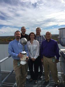
The Understory sensor, RTi (real time information), consists of a metallic ball similar in size to a soccer ball attached to a metal rod that is fixed to a base plate. It’s powered by solar panels and has embedded wireless technology to upload data directly to the company’s cloud platform.

Amica’s RTi sensor sits atop one of the buildings at its corporate headquarters in Rhode Island where it measures temperature, wind speed and hail impact in real time. A television monitor allows employees to see exactly how windy it is at the rooftop level.
Adam Kostecki, claims officer in Amica’s claims executive department and a member of its enterprise innovation team, said the corporate headquarters sensor will aid in testing data reliability.
The insurer hopes that the data obtained from the sensor will help to more effectively handle future claims.
“This data can be used in our mapping platform to improve our understanding of severe weather events by incorporating ground-level observations,” Kostecki said. “With this detailed dataset, we hope to more accurately predict claim volumes, especially after hailstorms.”
Understory has already deployed networks of RTi sensors in Kansas City, Boston and Dallas, with additional deployments planned through 2017. Prime locations are areas with significant exposure to strong wind and damaging hail.
The proprietary weather sensor was invented by the co founders of the company, Alex Kubicek, Understory CEO and Bryan Dow.
“The idea behind the sensors was to create a cost effective network so that we can measure data in a granularity that hasn’t been accessible before,” said Kubicek.
He explained that the sensor takes solid state measurements.
“There’s no moving parts, it’s actually taking in essentially the atmospheric force in the area, so a gust of wind or a direct impact from a hailstone or the impact on individual raindrops,” said Kubicek.
The sensors are placed every three to four miles inside a metropolitan area, depending on the density of the population, as well as some other climatic variables, Kubicek said.
“That’s how we’re able to actually see what’s happening directly inside the city property by property basis,” Kubicek said.
The information collected is combined with other third party data in order to create an entire data set.
The data is much more complete than what is available from ground weather stations, Kubicek said.
“All the ground stations that the government puts out, those are usually about 25 to 100 miles apart, so you can’t do a lot with what’s happening on the ground and they also don’t measure hail,” he explained.
Any hail data that is obtained from the ground stations is typically measured 45,000 feet to 60,000 feet above the ground, the Understory co-founder said.
“That doesn’t always translate to what’s happening on the ground,” Kubicek said. “That’s how we’re able to really fill that in by having weather stations that are on the ground, measuring that at root level.”
The company monitors its own data.”We own and operate the networks ourselves just so we know that the data quality is perfect from where it’s sighted, that you have the data that’s processed so that we’re providing the cleanest data on the outset,” explained Kubicek.
Insurers like Amica and American Family, who has also partnered with the weather data and analytics company, can pull the information off of a cloud platform or it can be integrated within an insurer’s own system.
The sensors can withstand up to two and half inch sized hail, about the size of a baseball.
“If they get hit with grapefruit size hail, that would probably take them out,” said Kubicek.
Kostecki said the two companies had been working together for a couple of years.
Understory reached out to Amica as a result of the insurer’s exploration of mapping data through geographic information system (GIS) technology.
“By mixing up a number of different data sources, third party weather data sources, for example, with our customer data, we found especially after a hail scenario, that GIS really helped us to more accurately project out how many claims could be reported from the event,” said Kostecki.
He said this allowed the insurer to proactively manage claims by predicting how many might be reported and staffing appropriately.
It also helped improve the customer experience, he said.
“We’ve had a web based GIS system for maybe a little bit over three years now,” Kostecki said. “Our initial foray into GIS was really around predicting claims volumes after catastrophic events, but what we found was it had a tremendous potential to improve our operations even after really localized events like wildfires or small hailstorms or tornadoes.
That’s really where we saw the usage when we integrated it, not just into our catastrophe planning but into our day to day operations, we found significant benefit from GIS.”
Instead of looking at just one hail claim, the platform allows the insurer the ability to view claims from the perspective of the storm.
“Downward on the property, you have a much different view, because you can see things collectively as opposed to each individual property,” Kostecki explained.
While the sensors have been place about two years, this spring was the first time where there was a significant hail event that moved over an area where Amica had a high policy concentration, Kostecki added.
“What we did after the event in March was we looked at the data, we pulled that into our mapping platform, we compared it with policies and claims that have been reported from the event, then we identified some differences between the hail model that we’ve been using all along, from the cloud perspective, versus what was observed at the ground level,” said Kostecki.
The companies are reviewing the data obtained from the sensors to identify how it improves the insurer’s results over the existing data they currently have.
“From an operational perspective, hail catastrophes are a major challenge because you deal with a large influx of calls to your call center in a small period of time,” Kostecki explained. “After a hail event, you need to scale up very quickly.”
The Amica claims officer said the company is researching how to proactively reach out to customers after a hail event, rather than customers calling in to report claims.
“If we can generate a text message or an email to the customer and direct them to our online channel, we can be more efficient at servicing those customers,” said Kostecki.
Understory has a variety of staff, including a real estate team that locates sites, a data science team as well as software and hardware teams.
The co-founder and Understory CEO is excited at the prospect of collecting data not seen before.
“A lot of the things that we’re really excited about is just in the nature of how our sensors actually measure hail. It actually measures the direct force of the impact of hail. That’s really allowing us to think about hail completely differently than the industry has in the past,” Kubicek explained. “Most of the things that you’re looking at are hail size, but that’s really not what’s important. It’s how hard that’s actually hitting the roof.”
Determining the force of hail and which areas are being hit harder than others aids in understanding why some pockets of hail claims occur in areas not seen with traditional radar data, Kubicek said.
Was this article valuable?
Here are more articles you may enjoy.

 Founder of Auto Parts Maker Charged With Fraud That Wiped Out Billions
  Navigators Can’t Parse ‘Additional Insured’ Policy Wording in Georgia Explosion Case
  China Bans Hidden Car Door Handles in World-First Safety Policy
  FM Using AI to Elevate Claims to Deliver More Than Just Cost Savings