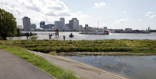
NEW ORLEANS — The river that drains much of the flood-soaked United States is still running far higher than normal, menacing New Orleans in multiple ways just as the hurricane season intensifies.
For months now, a massive volume of water has been pushing against the levees keeping a city mostly below sea level from being inundated. The Mississippi River has run past New Orleans at more than 11 feet (3.4 meters) above sea level for more than 200 days.
“The big threat is water getting through or underneath,” said Nicholas Pinter, an expert on river dynamics and flood risks who’s studied levee breaches across the nation. “The longer the duration, the greater the threat.”
Locals walked up levees from Baton Rouge to New Orleans to see the river for themselves as Tropical Storm Barry briefly menaced Louisiana last month, but the real damage runs underneath, experts say: All that rushing floodwater can scour levees along their foundations, causing damage in places that can’t easily be seen.
“That ultimately could undermine the levee as well and cause a breech or a failure,” said Cassandra Rutherford, assistant professor of geotechnical engineering at Iowa State University.
The federal agency that maintains the levees is aware of the risks. But Ricky Boyett, spokesman for the New Orleans office of the U.S. Army Corps of Engineers, said the corps is confident that South Louisiana river levees are in great condition, with improvements made since 2011.
“If there’s a silver lining going into hurricane season with the river this high for this long, we’re entering the hurricane season having done 200 inspections of the levee since February,” Boyett said.
Inspectors have been checking at least twice a week for parked barges, stuck debris or other potential trouble, such as tire ruts or damage from feral hogs on grassy surfaces. They also look for water seeping through, and for sand boils — spots where water tunneling below a levee seems to bubble out of the ground.
Concrete mats armor underwater areas likely to be eaten away by the river’s current, Boyett said. Sand boils get ringed with sandbags until the water pressure on both sides equalizes, stopping the flow. And because some permanent repairs can’t be made until river levels drop, dangerous seepage gets stopgap coverage: About 63,000 large sandbags have been used since March on one 300-foot-long (91.5-meter-long) seepage area upriver of Baton Rouge, he said.
Even so, experts who study flowing water say there’s a risk the river could rise above the tops of some levees in the New Orleans area, if a hurricane pushes enough storm surge up the swollen river. The city’s levees held the river back in the great flood of 1927 and haven’t been topped since then, Boyett said.
A Category 4 hurricane striking the Louisiana coastline can produce a 20-foot (6.1-meter) storm surge , the National Oceanic and Atmospheric Administration says. However, that surge’s size at New Orleans, more than 100 winding river miles up from the coast, would be reduced by the Big Muddy’s push seaward.
The levees range in height from 20 to 25 feet (6 to 7.5 meters). While river levels are finally falling, the National Weather Service projects the Mississippi will remain well above average at about 11 feet (3.4 meters) above sea-level at New Orleans this week as hurricane season heats up.
“We really have a heightened concern this year,” said Scott Hagen, of Louisiana State University’s Center for Coastal Resiliency.
For most of the past three decades, the Mississippi has run about 3 to 5 feet (1 to 1.5 meters) high in mid-August at New Orleans’ Carrollton gauge.á The last time it was near this high was 11.4 feet (3.5 meters) in August 2015, a year when no significant tropical weather reached Louisiana’s coast. It was 12.2 feet in 1993, another year Louisiana’s coast escaped harm.ááá
When Katrina formed as a tropical storm in the Bahamas on Aug. 24, 2005, the river stage in New Orleans was just 2.44 feet (0.74 meters) above sea level. It rose to 3.6 feet (1.1 meters) the day before Katrina devastated the city in 2005.
Katrina knocked out an automatic station that would have measured peak surge at the river’s mouth, but an analysis by the Federal Emergency Management Agency indicates the surge reached nearly 28 feet at Pass Christian, Mississippi. Surge pushed the Mississippi River up to 11.6 feet (3.5 meters) at New Orleans _ not a threatening height with the river low. But surge from the brackish lakes to the city’s north and east reached 19 feet, overtopping or breaching those levees and flooding 80 percent of the city with water as much as 20 feet deep in places.
The vast majority of the $14.6 billion spent on flood controls as a result of Katrina went not to the river levees, but to shore up and block areas that failed.
“I would assume major problems on the river if we had a high river with a Katrina event,” said Jeffrey Graschel, with the National Weather Service’s Lower Mississippi River Forecast Center.
The possibility of a punishing storm surge meeting a swollen Mississippi in New Orleans is a different threat, one likely to become more common as the planet warms, spawning longer-lasting floods and earlier hurricanes.
Barry was the first hurricane to menace when the river was as high as it was in July, Boyett said.
In 1929, the year construction started on the spillway that caps the river’s height at New Orleans, the Mississippi topped at 19.99 feet (6.1 meters) in June, Boyett said. But that year saw only five Atlantic tropical systems, with two hurricanes in the Gulf, National Hurricane Center data show — and both stayed away from Louisiana. NOAA forecasters now expect 10 to 17 named storms this year, including five to nine hurricanes.
Opening spillways upriver from New Orleans can’t fix this, because they were designed to keep water flowing at a manageable rate, not to quickly drop river levels, which could cause mudslides when levees don’t dry out as fast as the water falls, Boyett said.
The changing climate means this problem could become an annual threat.
“Flooding is never a one-time thing. We’re just waiting for the next one,” said Pinter, an associate director of the University of California Davis Center for Watershed Sciences. “Given model predictions for climate change and rising sea levels and suggestions that hurricanes are maybe getting more intense, it’s something we have to keep an eye on.”
Was this article valuable?
Here are more articles you may enjoy.


 One out of 10 Cars Sold in Europe Is Now Made by a Chinese Brand
  US Will Test Infant Formula to See If Botulism Is Wider Risk
  Why 2026 Is The Tipping Point for The Evolving Role of AI in Law and Claims
  Portugal Rolls Out $2.9 Billion Aid as Deadly Flooding Spreads