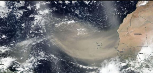
Summer brings long hot days and afternoon thunderstorms across the U.S. Now you can add African dust to the mix.
Two large blobs of dust blown off of Africa’s Sahara Desert are on their way to North America, driven by the same high pressure system that pushes hurricanes across the same route. The largest is already over the Gulf of Mexico and parts of Florida. The second is in transit in the deep Atlantic.
The year has brought a global pandemic, murder hornets, record high temperatures and the threat of a wild hurricane season to the U.S., as well as out-of-control forest fires and locusts in other parts of the world. But while the two dust clouds are big, they aren’t apocalyptic, said Bob Oravec, senior branch forecaster at the U.S. Weather Prediction Center.
“This is a common occurrence in the summer time, especially when there is a big high pressure system in the Atlantic,” Oravec said by phone. “It tends to push the Saharan dust off Africa.”
There are currently no quality alerts in the U.S. because of the dust. But the current clouds are the most intense since 2002, when technology first allowed science to closely monitor these disturbances, said Dan Kottlowski, a meteorologist with AccuWeather Inc. in State College, Pennsylvania.
This year’s activity came about because the east African jet stream has been highly energetic, touching off more storms that caused the dust to swirl as high as 20,000 feet into the atmosphere, he said.
The high pressure system that pulls the dust into the Atlantic spins clockwise around the basin, which means that disturbances that originate in Africa will regularly move westward toward North America. The big headline makers are usually tropical storms and hurricanes that hitch a ride on this conveyor belt, but dust from the world’s largest hot desert can make the trip as well.
The Atlantic hurricane season has already had a quick start with four storms named and two tropical storms hitting the U.S. Forecasters are almost unanimous that the rest of the season, which peaks between late August to early October, will be extreme.
The intensity of the dust could also be another indicator of that, Kottlowski said. The active jet stream is adding to more intense storms, and when the conditions are right later in the summer that could help fuel hurricane season, he said.
Was this article valuable?
Here are more articles you may enjoy.


 Founder of Auto Parts Maker Charged With Fraud That Wiped Out Billions
  Elon Musk Alone Can’t Explain Tesla’s Owner Exodus
  Credit Suisse Nazi Probe Reveals Fresh SS Ties, Senator Says
  Canceled FEMA Review Council Vote Leaves Flood Insurance Reforms in Limbo