MINNEAPOLIS (AP) — Major winter storms continued to dump on California and a stretch of the Upper Midwest on Wednesday, with heavy rain on the West Coast and heavy snow in the north-central states — as a possible tornado damaged homes in the South.
A Delta jet went off an icy taxiway after landing in a snowstorm in Minneapolis on Tuesday but no passengers were injured, the airline said. The flight from Los Cabos, Mexico, had landed safely, but then the nose gear of the plane “exited the taxiway while turning toward the gate due to icy conditions,” Delta Airlines said.
It took about an hour to get the 147 passengers off the plane and bused to the terminal, said Jeff Lea, a spokesman for the Metropolitan Airports Commission, the Star Tribune reported.
The airport had received 10 inches (25 centimeters) of snow as of 6 a.m. Wednesday, the National Weather Service said. Another 3 to 5 inches (7 to 12 centimeters) was possible. Multiple schools were closed Wednesday in Minnesota and western Wisconsin as steady snow fell in the region.
To the south, a possible tornado damaged homes, downed trees and flipped a vehicle on its side in Montgomery, Alabama, early Wednesday. Christina Thornton, director of the Montgomery Emergency Management Agency, said radar indicated a possible, but unconfirmed, tornado. The storm had extremely high winds and moved through the area before dawn, she said.
Severe weather that swept Illinois on Tuesday produced at least six tornadoes, the largest number of rare January tornadoes recorded in the state since 1989, the National Weather Service said.
Five of the tornadoes occurred in central Illinois in or around the city of Decatur, while the sixth touched down near the Ford County community of Gibson City, the weather service said Wednesday.
Staff from the agency’s Chicago office planned to survey storm damage Wednesday in the Gibson City area, where at least two homesteads suffered damage and power lines were knocked down.
On the West Coast, the snowpack covering California’s mountains is off to one of its best starts in 40 years, officials announced Tuesday, raising hopes that the drought-stricken state could soon see relief in the spring when the snow melts and begins to refill parched reservoirs.
Roughly a third of California’s water each year comes from melted snow in the Sierra Nevada, a mountain range that covers the eastern part of the state. The state has built a complex system of canals and dams to capture that water and store it in huge reservoirs so it can be used the rest of the year when it doesn’t rain or snow.
Statewide, snowpack is at 174% of the historical average for this year, the third-best measurement in the past 40 years. Even more snow is expected later this week and over the weekend, giving officials hope for a wet winter the state so desperately needs.
In Southern California, forecasters said “all systems go” for a major storm to sweep over the area Wednesday and Thursday, with peak intensity occurring from midnight to noon Thursday.
The storms in California still aren’t enough to officially end the drought, now entering its fourth year. The U.S. Drought Monitor showed that most of the state is in severe to extreme drought.
“We know that it’ll take quite a bit of time and water to recover this amount of storage, which is why we don’t say that the drought is over once it starts raining,” said Jeanine Jones, drought manager for the California Department of Water Resources.
–Associated Press journalist Rick Callahan contributed to this report from Indianapolis.
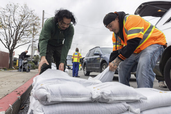
Top photo: Fernando Bizarro, left, collects sandbags from an emergency distribution center to prepare for an upcoming storm, Tuesday, Jan. 3, 2023, in San Francisco. (Santiago Mejia/San Francisco Chronicle via AP)
Was this article valuable?
Here are more articles you may enjoy.


 Why 2026 Is The Tipping Point for The Evolving Role of AI in Law and Claims
  UBS Top Executives to Appear at Senate Hearing on Credit Suisse Nazi Accounts
  Cape Cod Faces Highest Snow Risk as New Coastal Storm Forms
  Portugal Rolls Out $2.9 Billion Aid as Deadly Flooding Spreads