The hurricane season continues to look like it will be a highly active one, as a potent and portentous weather pattern continues to take shape, an AccuWeather meteorologist told Claims Journal on Friday.
“It certainly looks like it’s going to be a very busy season; I would be certainly concerned more than average if I lived along the Texas coast, the North Florida Panhandle area, South Florida and into the Carolinas,” Alex DaSilva, lead hurricane forecaster for AccuWeather, said. “Those are kind of the areas that we are most concerned with this season and that have a higher-than-average risk of impacts.”
How concerned should we be?
“I would be more concerned than I would be in an average season, let’s put it that way,” he said.
Related: Catastrophe Bond Sales Soar as Markets Brace for Unusually Active Hurricane Season
The season has been looking to be above and beyond average for several months now.
The National Oceanic and Atmospheric Administration last month forecast an 85% chance of an above-average Atlantic hurricane season, with up to 25 named storms. Colorado State University’s tropical meteorology project in April forecast 23 named storms, 11 hurricanes and five major hurricanes.
AccuWeather meteorologists in March forecast an above-average Atlantic hurricane season with as many as 20 to 25 named storms, a forecast that DaSilva said hasn’t changed much in the last few months. However, the new message he’s now driving home was that weather patterns continue to develop in a way that make the hurricane season look more threatening.

“What has changed is a change from El Niño to La Niña,” DaSilva said. “We are now out of the El Niño phase and now we are in what we call an ENSO neutral phase (the El Niño-Southern Oscillation transition state between warm and cool phases). So, we’re in the neutral phase now, which is what we expected to happen. Then, at some point, probably late summer, we’re expected to go into La Niña.”
The current concern has to do with rising sea surface temperatures. Last year was the warmest year on record for sea surface temperatures across the Atlantic basin.
“If you kind of took a whole average of the entire basin, this year so far we are outpacing 2023,” DaSilva said. “So, if we remain on the same kind of pace that 2023 had, we will outpace that and this will become the new warmest year on record for ocean temperatures – regardless of if it’s first or second, it doesn’t really matter, it’s exceptionally warm and almost the entirety of the Atlantic basin is above average for water temperatures, and so that gives storms plenty of fuel.”
The developing patterns stir fears of the possibility of another storm like Hurricane Ian in 2022, a destructive Category 5 hurricane that caused widespread damage across western Cuba, Florida, and the Carolinas.
“That’s kind of the biggest fear I have is that what happened with that storm is it kind of blew up in the Gulf of Mexico before going inland,” DaSilva said. “There’s so much warm water that these tropical systems thrive on that very warm water, and since it’s so warm it basically primes the basin for the potential for rapid intensification, so that’s kind of the real big message.”
AccuWeather’s next big hurricane update is set for Aug. 1, followed by one more update on Sept. t. The first tropical storm of the season occurs on average around June 20, and the average first hurricane of the season is typically around Aug. 11. On average, the first major hurricane (Category 3 or higher) occurs around Sept. 1, which is considered the heart of the hurricane season, according to AccuWeather.
Now is often literally the quiet before the storm.
“Just because we’re not seeing a whole lot of action right now doesn’t mean things can’t ramp up quickly, and we’re watching something in the southwestern Gulf of Mexico right now, in the Bay of Campeche, which may bring some rain to South Texas here next week, so that has a chance of developing between Monday and Wednesday of next week here,” DaSilva said. “We might you be right near average in terms of the first storm of the season if that does develop.”
It’s a lot to consider for anyone. And for property insurers in particular, there are a lot of properties in harm’s way to eye in their portfolios.
More than 32.7 million residential properties are at risk of moderate or severe damage sustained from hurricane-force winds from Texas to Maine. The mind-boggling number of at-risk homes in CoreLogic’s 2024 Hurricane Risk Report, which comes as an ominous 2024 Atlantic hurricane season approaches, equates to a combined reconstruction cost of $10.8 trillion.
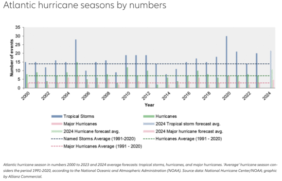
Global insurer Allianz Commercial recently released its annual risk article on the season’s outlook.
That outlook calls out the good fortune in 2023. That was an above-average season, though only eight storms made landfall. Most of the storms, referred to as “fish storms,” stayed at sea.
The Allianz report summarizes the predicted number of tropical storm events for 2024 by six organizations. All of the forecasts indicate a season ahead to watch.
“Based on their forecasts, the 2024 season is expected to be well above the 1991-2020 average, with 15 to 28 tropical storms, eight to 16 hurricanes and two to seven major hurricanes,” the report states. “The NOAA has issued its highest-ever pre-season forecast. While there is high confidence the 2024 Atlantic hurricane season will be very active, uncertainties remain around factors like the El Niño Southern Oscillation, or ENSO, and outbreaks of dry, dusty Saharan air, among other factors.”
Was this article valuable?
Here are more articles you may enjoy.


 LA County Told to Pause $4B in Abuse Payouts as DA Probes Fraud Claims
  Hackers Hit Sensitive Targets in 37 Nations in Spying Plot
  Elon Musk Alone Can’t Explain Tesla’s Owner Exodus
  Berkshire Utility Presses Wildfire Appeal With Billions at Stake