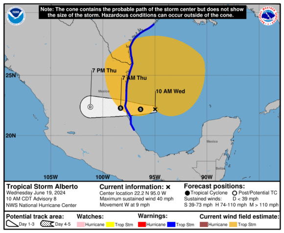
Tropical storm Alberto has caused flooding and more than three feet of storm surge in parts of coastal south Texas but is not expected to strengthen to hurricane force, meteorologists say.
Alberto is the first named storm of the 2024 Atlantic Hurricane Season. The storm developed in the western Gulf of Mexico earlier in the week. By Wednesday morning the storm reached maximum sustained winds of 40 mph.
Alberto was about 275 miles southeast of Brownsville, Texas at the time it strengthened to a tropical storm, said AccuWeather chief on-air meteorologist Bernie Rayno. The storm is likely to make landfall near Tampico, Mexico on Thursday morning.
Related: Experts: Atlantic Hurricane Season Potential on Par with 2005, 1995

A tropical storm watch is in effect for the Texas coast from San Luis Pass southward to the mouth of the Rio Grande and the northeastern coast of Mexico south of the mouth of the Rio Grande to Tecolutla.
Related: Potent Hurricane Weather Pattern Continues to Take Shape, Forecaster Says
“Even though the center of circulation is south of Texas, it has a pretty large circulation. That’s why we’re seeing impacts in coastal and southern Texas. There are going to be bands of heavy rain in Corpus Christi today with thunder and lightning,” said Rayno. “Austin and San Antonio are going to get soaking rains this afternoon and tonight. Corpus Christi, Brownsville, and parts of the Rio Grande Valley will be drenched with 8 to 12 inches of rain. This is an impactful tropical storm. It’s not making landfall in the United States, but it’s certainly having big impacts in Texas.”
The 2024 hurricane season is forecast to be a highly active one. Last month the National Oceanic and Atmospheric Administration projected up to 25 named storms.
Was this article valuable?
Here are more articles you may enjoy.

 Navigators Can’t Parse ‘Additional Insured’ Policy Wording in Georgia Explosion Case
  Elon Musk Alone Can’t Explain Tesla’s Owner Exodus
  LA County Told to Pause $4B in Abuse Payouts as DA Probes Fraud Claims
  FM Using AI to Elevate Claims to Deliver More Than Just Cost Savings