Hurricane Beryl churned toward Jamaica with violent winds, heavy rains and a life-threatening storm surge that could cause more than $1 billion in damage.
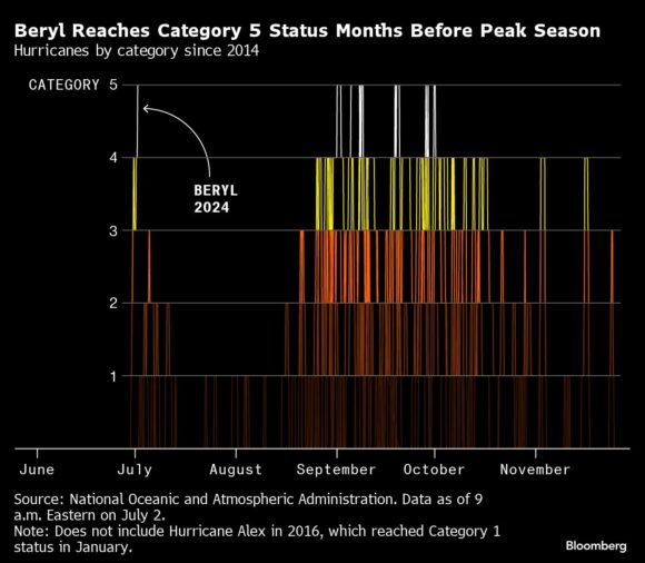
Beryl’s winds roared at 145 miles (230 kilometers) per hour early Wednesday, making it a Category 4 storm, the National Hurricane Center said in an advisory. It has weakened slightly after becoming the Atlantic’s earliest Category 5 hurricane on record late Monday, but it remains extremely dangerous.
“Beryl is forecast to be at or near major hurricane intensity while it passes near Jamaica later today and the Cayman Islands tonight or early Thursday,” the NHC said. “Additional weakening is expected thereafter, though Beryl is forecast to remain a hurricane in the northwestern Caribbean.”
The eye of the storm was located about 185 miles east-southeast of Kingston, according to the notice at 5 a.m. New York time.
“This is at least a billion-dollar event for Jamaica,” said Chuck Watson, a disaster modeler with Enki Research. If Beryl’s track shifts, damages could be even higher. Prime Minister Andrew Holness has urged residents to prepare by stocking up on supplies and food.
The Associated Press reported at least six deaths as the hurricane raged across the southeast Caribbean. In Jamaica, the storm surge could raise some coastal water levels by as much as 9 feet, and rainfall could reach 12 inches in some areas, according to the NHC.
 Beryl Reaches Category 5 Status Months Before Peak Season | Hurricanes by category since 2014
Beryl made landfall Monday on Carriacou, the second-largest of Grenada’s islands. Authorities reported widespread damage, though power was being partially restored and the Grenada Airports Authority on Wednesday showed both arrivals and departures.
“To some extent we dodged a bazooka,” Prime Minister Dickon Mitchell said earlier. “We have to count our blessings.”
This is a modal window.The media could not be loaded, either because the server or network failed or because the format is not supported.
US President Joe Biden said he is following the storm’s progress.
“People impacted, islands and communities are in our prayers, and we stand by to provide assistance,” he said during remarks at the DC Emergency Operations Center. “Extreme weather events drive home a point that I’ve been saying for so long: ignoring climate change is deadly and dangerous and irresponsible.”
While the humanitarian losses are still being assessed, there are signs Beryl is having an impact on markets.
European insurers’ stocks fell as the storm raised worries that an unusually active storm season will drive up claims. Munich Re and Swiss Re, the two biggest reinsurers, on Wednesday continued their slide Wednesday, after dropping 3.3% and 4% respectively in trading Tuesday.
There is a risk that a significantly weaker Beryl will spiral into the northern Gulf of Mexico next week. The storm has a 30% to 40% chance of reaching the upper Gulf as a tropical storm or weak hurricane, but it probably wouldn’t cause any damage, said Matt Rogers, president of the Commodity Weather Group LLC.
“I think it may stay farther south into Mexico like Alberto and Chris did, particularly if it starts to weaken in coming days as projected, but the odds of an upper Gulf entry have increased,” Rogers said.
In the last two weeks, Tropical Storms Alberto and Chris developed off Mexico’s east coast and quickly made landfall without causing extensive damage.
Typically, the first hurricane arrives in the Atlantic by Aug. 11 and the first major storm — Category 3 or stronger on the Saffir-Simpson scale — comes by Sept. 1, according to the National Hurricane Center. The other Category 5 system to occur in the Atlantic basin during July was Emily in 2005.
“Unfortunately, Beryl is breaking records that were set in 1933 and 2005 — two of the busiest Atlantic hurricane seasons on record,” said Phil Klotzbach, a senior research scientist at Colorado State University. It likely points to a hyperactive season, he added.
Was this article valuable?
Here are more articles you may enjoy.


 Why 2026 Is The Tipping Point for The Evolving Role of AI in Law and Claims
  Credit Suisse Nazi Probe Reveals Fresh SS Ties, Senator Says
  Canceled FEMA Review Council Vote Leaves Flood Insurance Reforms in Limbo
  Charges Dropped Against ‘Poster Boy’ Contractor Accused of Insurance Fraud