
The National Oceanic and Atmospheric Administration, which has already forecast an extremely active hurricane season, is now saying it could rank among the busiest on record.
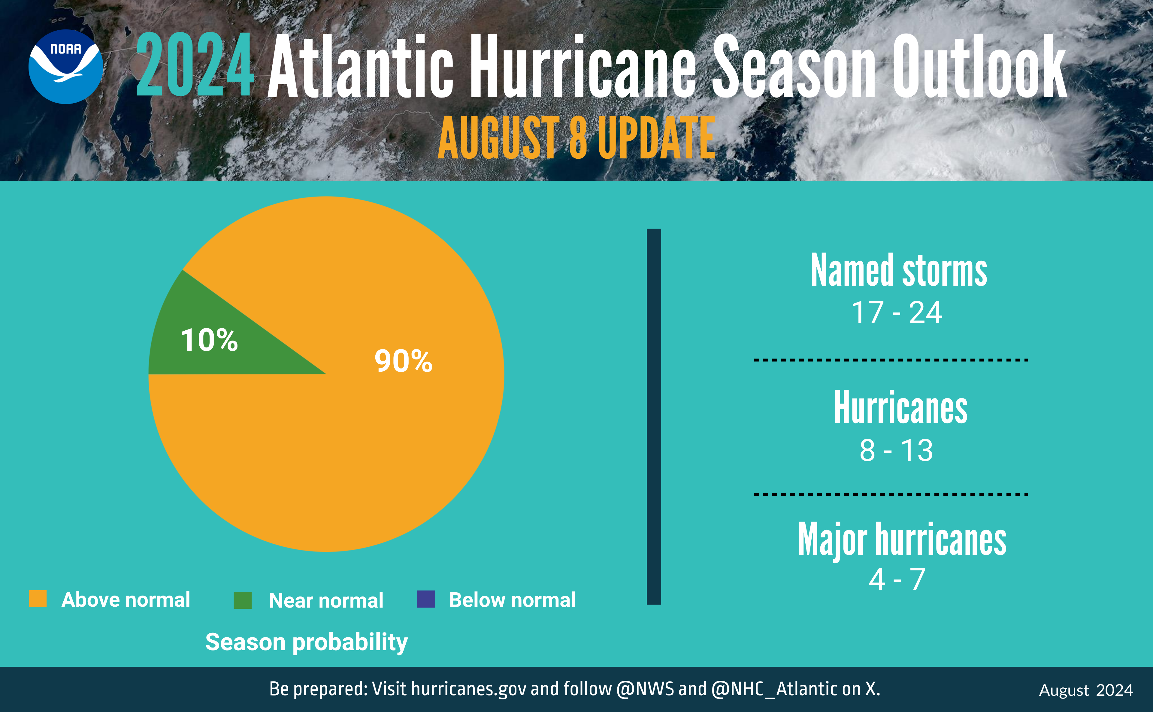
In a mid-season hurricane outlook update, NOAA’s Climate Prediction Center forecasters updated the number of expected named storms to 17 to 24 (with winds of 39 mph or greater), of which eight to 13 could become hurricanes (winds of 74 mph or greater), including four to seven major hurricanes (winds of 111 mph or greater).
Related: Gallagher Re: Insured Losses From Hurricane Debby to Be ‘Very Manageable’
In the Atlantic basin, a typical season will yield 14 named storms, of which seven become hurricanes and three become major hurricanes, according to NOAA.
The updated outlook is similar to the initial outlook issued in May, but it includes totals for the entire six-month hurricane season, including the four named storms—two tropical storms and two hurricanes—to date.
Related: Storm Debby Threatens Carolinas With Possible Floods, Tornados
Tropical Storm Alberto formed on June 17, and it brought nearly a foot of rain to parts of Texas and New Mexico, triggering flash flood emergencies. On July 1, Hurricane Beryl became the earliest category-5 storm on record in the Atlantic basin.
Hurricane season runs from June 1 through November 30.
“The hurricane season got off to an early and violent start with Hurricane Beryl, the earliest category-5 Atlantic hurricane on record,” state NOAA Administrator Rick Spinrad.
Related: AccuWeather: Tropical Threat Developing in Atlantic Could be Next Named Storm
Atmospheric and oceanic conditions continue to support an above-normal 2024 Atlantic hurricane season. The administration forecasts a 90% probability of an above-normal season, a 10% chance of a near-normal season and a negligible chance of a below-normal season.
NOAA says the Atlantic ocean basin is expected to be active due to factors including:
- Warmer-than-average sea surface temperatures in the tropical Atlantic Ocean and Caribbean Sea.
- Reduced vertical wind shear.
- Weaker tropical Atlantic trade winds.
- An enhanced west African monsoon.
The Atlantic basin is in a continued warm phase of the Atlantic Multi-Decadal Oscillation, which reappeared in 1995 and has been favoring more active hurricane seasons ever since. Another factor this year is the possibility of La Niña developing in the coming months, which can further weaken the wind shear over the Atlantic Basin, which enables storms to develop and intensify, according to NOAA.
Was this article valuable?
Here are more articles you may enjoy.
 LA County Told to Pause $4B in Abuse Payouts as DA Probes Fraud Claims
  Hackers Hit Sensitive Targets in 37 Nations in Spying Plot
  Canceled FEMA Review Council Vote Leaves Flood Insurance Reforms in Limbo
  Founder of Auto Parts Maker Charged With Fraud That Wiped Out Billions
Want to stay up to date?
Get the latest insurance news
sent straight to your inbox.