One forecast calls for Francine to intensify into a Category 2 hurricane in the next 24 hours before hitting the Louisiana coast with storm surge of up to 15 feet, while a catastrophe modeler says the surge could cause flooding that puts more than 125,000 properties at risk.
Francine is expected to produce maximum sustained winds of 96 to 110 miles per hour, according to an AccuWeather forecast. Meteorologists are forecasting 100 to 120 mph winds when Francine makes landfall on Wednesday. Maximum wind speeds could reach 130 mph.
Flash flooding is likely with 8 to 12 inches of rainfall expected. Tornadoes embedded in rain bands are possible east of the storm track, according to AccuWeather.
AccuWeather’s forecast calls for a more intense hurricane than other forecasts.
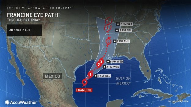
“While the National Hurricane Center and some other sources lowered their wind intensity forecast to a Category 1 hurricane, AccuWeather expert meteorologists have maintained their forecast of Francine reaching Category 2 intensity prior to landfall,” stated AccuWeather Chief Meteorologist Jon Porter. “This is due to the fact that the storm will spend time in an environment with very warm water, high ocean heat content, and low wind shear through Wednesday morning.”
AccuWeather meteorologists say Francine could produce a widespread zone of 6 to 10 feet of storm surge along much of the Louisiana coast and parts of western Mississippi.
They expect a widespread 4 to 8 inches of rainfall across much of Louisiana, eastern Arkansas, western Mississippi and southwest Tennessee. A zone of 8 to 12 inches of rainfall is forecast across a pocket of southern and central Louisiana.
Property data provider and modeler CoreLogic reported that more than 125,000 properties are at risk from flooding due to the storm surge, while nearly 67,000 residential properties with a combined reconstruction cost value of $15.9 billion are at risk of storm surge flooding if Francine makes landfall as a Category 1 hurricane and maintains its current forecasted track.
The largest concentration of residential properties at risk of storm surge is in the Houma-Thibodaux metro area of Louisiana in the eastern part of the state. If the current storm track holds, then the Houma-Thibodaux area will be on the eastern side of the storm center, where the worst severe storm surge typically occurs, according to CoreLogic.
Was this article valuable?
Here are more articles you may enjoy.
 Elon Musk Alone Can’t Explain Tesla’s Owner Exodus
  Canceled FEMA Review Council Vote Leaves Flood Insurance Reforms in Limbo
  FM Using AI to Elevate Claims to Deliver More Than Just Cost Savings
  Credit Suisse Nazi Probe Reveals Fresh SS Ties, Senator Says
Want to stay up to date?
Get the latest insurance news
sent straight to your inbox.