Climate change made Southern California’s dangerous wildfire conditions in early January 35% more likely than they would have been before the industrial era, according to a new analysis by the scientific group World Weather Attribution.
Greenhouse gas pollution raised temperatures, made drought more likely and extended the length of fire season, contributing to the most destructive fire disaster in US history, killing at least 28 people and destroying more than 16,000 structures. The fires were also 6% more intense because of climate change, the analysis found.
Related: LA Wildfires by the Numbers: Losses, Ratings, and Rates
“The fires that we saw were within the range of fire size recorded historically for Southern California,” said Roop Singh, a climate risk advisor with the Red Cross Red Crescent Climate Centre and WWA contributor. “It’s their proximity to densely populated urban areas that really led to their significant impact.”
Scientists now routinely analyze extreme weather events for a climate change influence. Dusting for climate fingerprints on heat waves has become so straightforward that it even can be automated. But wildfires are more complicated than heat waves: They depend on temperature, rainfall, humidity, vegetation growth and windiness all aligning, over days to years. And fires in Southern California present an even harder puzzle. The region’s Mediterranean climate is prone to wild fluctuations — wet and dry years, strong and gentle winds. Its cramped landscape of steep mountains, brush-covered foothills, cities and hybrid woodland-residential areas is hard for climate models to parse.
So the 32 WWA experts broke the disaster down into three main factors: fire weather, recent precipitation and when the dry season ends (which it finally did this week).
A fire weather index for Los Angeles peaked on Jan. 8. That’s a measure of dryness in plants and soil, gleaned from temperature, humidity, wind speed and precipitation. The scientists found the conditions were rare but not unprecedented, occurring every 17 years or so. They occurred every 23 years before the atmosphere took on 50% more carbon dioxide.
The fire weather index “was very high but it was not unprecedented,” said Claire Barnes, a WWA researcher.
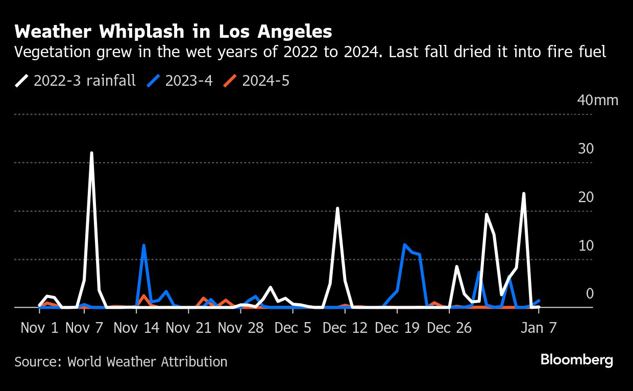
Recent rainfall, measured as a three-month average, is the WWA’s second key factor. California’s fire season typically peaks in late summer, when new springtime vegetation has had time to dry out, and ends when rain falls in October and November. Only this year, it didn’t.
The lack of rainfall might not have been quite as perilous, the scientists wrote, if it weren’t for the prior two years, which were unusually wet — including the once-in-a-generation rains that Hurricane Hilary dumped in August 2023. All that water led to massive plant growth in the region. Record-breaking heat this summer then sucked moisture out of all the vegetation, leaving it primed to ignite. Rising risks of “weather whiplash” — very wet followed by very dry conditions — were documented in a review paper published coincidentally two days after the fires began.
Related: Insurance Commissioner Orders Advance Payments on Claims for LA Wildfire Survivors
WWA scientists typically combine weather data and climate models to understand how rare a disaster is and how big an impact, if any, greenhouse gases had. The observations and models agreed for the spiking fire-weather index. But that’s not the case for precipitation.
The complexity of the Southern California landscape — cities, forested exurbs, brush-covered hills, all tightly wedged between steep mountains and the Pacific — was hard for many of the models to parse. That means the team was able to quantify observations, without necessarily assigning a specific number to the climate effect. For example, the observational record shows that the area gets dry seasons as bad as the fall of 2024 every 20 years now — or 2.4 times more often than before industrialization. Older and newer models disagree, though, on whether climate change will bring more or less precipitation to the area. The newer models suggest less; the scientists understand those as likelier be correct, but the model disagreement technically prevents them from making the official call.
“Qualitatively, we would say that the rainfalls, as well as the end of the drought season, that is changing because of climate change,” said Friederike Otto, WWA co-founder and a climate scientist at Imperial College London. “But we can’t quantify it because there, we just don’t have the models that are able to simulate this well enough.”
Another factor worsening this year’s fire weather was an El Niño, in place much of last year, which made the drought nearly twice more likely, compared with non-El Niño “neutral” years.
Fire season is also getting longer, the experts say, by 23 days a year, based on the observed data. The three-week extension makes it likelier that blazes will overlap with the winter Santa Ana winds, which is exactly what happened this month.
The Santa Anas carry hot, dry air from inland deserts down the mountains and toward the Pacific, fanning flames as they go. Early January’s powerful winds caused fires to spread rapidly and widely. There’s no clear climate influence on these winds.
Park Williams, a climate scientist at the University of California at Los Angeles, worked on the WWA study and a smaller-scale analysis published Jan. 13. He likened wildfires to an indoor light that turns on only when four switches are flipped simultaneously: vegetation, or fuel; heat; lack of precipitation; and ignition of some sort, almost certainly human this time of year. Heat is only the most obvious way for greenhouse gas emissions to make the event more likely, or worse, he said, and scientists no longer need supercomputers to understand that.
WWA also looked at fire simulations that compared the actual burning this month with what might have burned in a pre-fossil-fuel world. “Overburning” — what they call this additional climate-juiced destruction — amounted to 26% more land burned in Southern California and 45% along the coast.
ClimaMeter, an attribution group at France’s Institute Pierre-Simon Laplace, analyzes historical weather data without using climate models. They looked at the two-day weather conditions — including pressure, temperature, precipitation and wind — on Jan. 7 to Jan. 8 and found them to be 5C (9F) hotter, 15% drier and 20% windier than similar weather would have been from 1950 to 1986. The researchers attributed that to greenhouse gas pollution. Their analysis concluded that “natural variability likely played a minor role” in the fires, given the structure of their analysis.
The UCLA analysis estimates that fossil-fuel pollution was responsible for a quarter of the dryness in fire fuel, mostly a result of the record-hot summer. Even without climate change, the authors write, the fires would have been extreme.
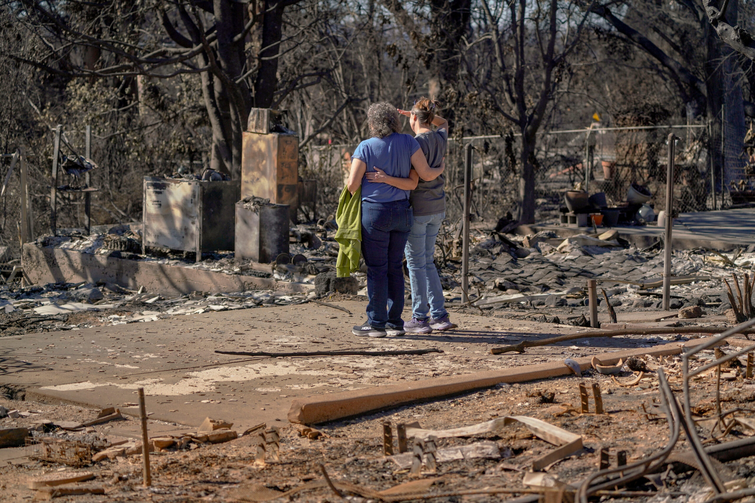
Top photo: Residents embrace outside the remains of their childhood home, destroyed by the Eaton Fire, in Altadena, California, on Jan. 23. Photographer: Kyle Grillot/Bloomberg.
Was this article valuable?
Here are more articles you may enjoy.
 Credit Suisse Nazi Probe Reveals Fresh SS Ties, Senator Says
  US Will Test Infant Formula to See If Botulism Is Wider Risk
  China Bans Hidden Car Door Handles in World-First Safety Policy
  Founder of Auto Parts Maker Charged With Fraud That Wiped Out Billions
Want to stay up to date?
Get the latest insurance news
sent straight to your inbox.