A Dutch-Texan team found that most Houston-area drowning deaths from Hurricane Harvey occurred outside the zones designated by government as being at higher risk of flooding: the 100- and 500-year floodplains. Harvey, one of the costliest storms in US history, hit southeast Texas on 25 August 2017 causing unprecedented flooding and killing dozens. Researchers at Delft University of Technology in the Netherlands and Rice University in Texas published their results today in the European Geosciences Union journal Natural Hazards and Earth System Sciences.
“It was surprising to me that so many fatalities occurred outside the flood zones,” says Sebastiaan Jonkman, a professor at Delft’s Hydraulic Engineering Department who led the new study.

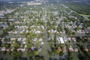
An aerial view shows extensive flooding from Harvey in a residential area in Southeast Texas, Aug. 31, 2017
Drowning caused 80 percent of Harvey deaths, and the research showed that only 22 percent of fatalities in Houston’s 4,600-square-kilometre district, Harris County, occurred within the 100-year floodplain, a mapped area that is used as the main indicator of flood risk in the US.
Flood zones, or floodplains, are low-lying areas surrounding rivers and streams that are subject to flooding. To assess flood risk for insurance purposes and to set development standards, US authorities outline floodplains for 100- and 500-year floods. These events have a 1 percent probability (100-year flood) and a 0.2 percent probability (500-year) of occurring in any given year.
“Hurricane Harvey was much larger than a 100- or 500-year flood, so flooding outside of these boundaries was expected,” says Jonkman. Rainfall totals in the week after the hurricane made landfall were among the highest recorded in US history, with over 1000 mm of rain falling in just three days in large parts of both Harris and surrounding counties. As a result, a report by Delft University found that “unprecedented flooding occurred over an area the size of the Netherlands.”
Nonetheless, it was surprising for the researchers to find that so many of Harvey’s fatalities happened outside the designated floodplains given that these zones are expected to be “reasonable predictors of high-risk areas,” according to Jonkman.
The research began within days of the storm: “We wanted to identify lessons that could be learned, for both Texas and the Netherlands, from Harvey’s impact and the local and government response to the flooding,” says study co-author Antonia Sebastian, a postdoctoral research associate at Rice University’s Severe Storm Prediction, Education and Evacuation from Disasters (SSPEED) Center, who was based at Delft University when Harvey struck.
The team compiled a database of fatalities, using official government records and media sources, which they analysed in the Natural Hazards and Earth System Sciences study published today. They concluded that at least 70 deaths occurred as a consequence of Hurricane Harvey, including 37 in Harris County. Of the Harris County deaths, eight were in the 100-year floodplain, 10 more fell within the larger 500-year floodplain, and 19 were recovered outside the 100- and 500-year zones. “The number of fatalities outside of the floodplains highlights how widespread flooding from Harvey really was,” says Sebastian.
The new study also shows that most fatalities – over 80 percent – were drownings, many occurring either in vehicles or when people were swept away while trying to get out of their cars. Six people died when their boat capsized during a rescue. The second largest causes of death were electrocution and lack of medical treatment, responsible for 6 percent of fatalities each.
About 70 percent of those killed by Harvey were men. The team thinks the reason behind the high percentage of male fatalities could be that men tend to show more risk-taking behavior, such as driving through flooded crossings or taking part in rescues.
The researchers hope their findings encourage authorities to identify high risk areas outside of the designated floodplains and to take preventive measures to reduce the number of victims in future floods, including closing low water crossings and underpasses during extreme flood events.
Jonkman says that the current flood maps will need to be improved, but that floodplains should not be abandoned as an indicator of high-risk areas. “Better communication of their purpose and limitations would help reduce risk.”
Source: Delft University of Technology
Was this article valuable?
Here are more articles you may enjoy.

 Canceled FEMA Review Council Vote Leaves Flood Insurance Reforms in Limbo
  Credit Suisse Nazi Probe Reveals Fresh SS Ties, Senator Says
  China Bans Hidden Car Door Handles in World-First Safety Policy
  Navigators Can’t Parse ‘Additional Insured’ Policy Wording in Georgia Explosion Case