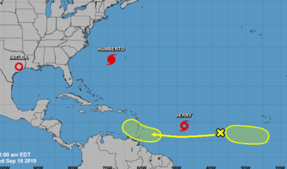
Imelda has lost some of its wind power, but continues to pour rain down on the U.S. Gulf Coast, with 12 to 15 inches already recorded and flood-prone Houston in its path.
Imelda is now a tropical depression, with winds falling to 30 miles (48 kilometers) per hour from 40 mph on Tuesday. Still, bands of heavy precipitation will soon drop as much as 12 inches in the Houston region, America’s oil, refining and chemical hub, with some areas getting up to 18 inches, said Lara Pagano, a forecaster with the U.S. Weather Prediction Center.
For Houston, the nation’s fourth-largest city, wet is much more of an issue than wind. Houston has a history of widespread flooding, with a dozen instances since 2015, including from Hurricane Harvey in 2017, according to the Houston-based Weather Research Center.
“The Houston to Galveston is an area that we are most concerned about,” according to Pagano, who is based in College Park, Maryland. “It is going to take a little while for this to get out of the area.”
In 2017, Hurricane Harvey paralyzed Houston with about 40,000 people forced out of their homes by flooding and 30,000 water rescues occurring during the storm. A record 60.6 inches (153.9 centimeters) fell near Nederland, Texas, about 90 miles east of Houston.
The six-month hurricane season, which ends Nov. 30, is in its most active phase, likely lasting through early October. Imelda was the ninth named storm this season and Tropical Storm Jerry, located in the mid-Atlantic, became the 10th on Wednesday.
Jerry has the potential to reach the Bahamas next week, according to the U.S. National Hurricane Center.
Since Jan. 1, the amount of rain hitting Houston has been a little less than normal, and Texas generally has been gripped by drought. So the expected deluge is somewhat of a turnaround for the region.
In the Pacific, Tropical Storm Lorena, with winds of 45 mph, is bearing down on Mexico’s west coast, including the port city of Manzanillo, home to a liquefied natural gas terminal. Tropical storm warnings have been posted.
–With assistance from Ben Sharples.
About the photo: This image from the National Weather Center’s website shows give tropical systems now active in the Atlantic Ocean.
Was this article valuable?
Here are more articles you may enjoy.


 These Five Technologies Increase The Risk of Cyber Claims
  Uber Jury Awards $8.5 Million Damages in Sexual Assault Case
  FM Using AI to Elevate Claims to Deliver More Than Just Cost Savings
  China Executes 11 People Linked to Cyberscam Centers in Myanmar