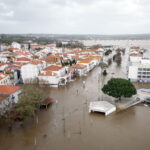
MIAMI — The highest tides of the year, known as king tides, are here again to flood roads, parks and the occasional home or business.
This year, in addition to the army of flood pumps coastal cities deploy to keep streets dry, the city of Miami is hoping that its residents will monitor the floods and report what they see. It’s part of a new partnership designed to fill in the gaps computer models can’t.
“We always say humans are the best sensors,” said Claudia Sebastiani, the Miami community manager with ISeeChange, a New Orleans-based firm that gathers resident-reported changes in their neighborhood — like flood hot spots — to help cities decide where to invest in flood protection.
King tides began in September, and some of the initial posts on the app show the now-familiar sight of deep puddles around storm drains and parking lots. This batch of high tides runs from October 14 to the 21, according to NOAA calculations. Tides have crept up higher and higher before peaking during high tide Oct. 16 and slowly shrinking.
“Tides are currently running .6 ft above NOAA predicted peaks, which (if that stays consistent) should result in a maximum king tide around 1.7 FT NAVD,” Alan Dodd, Miami’s chief resilience officer, wrote in an email.
These annual tides are naturally high thanks to the influence of the moon and the Gulf Stream, but sea level rise has turned them into the most visible symptom of climate change. The high tides are growing higher as oceans grow warmer. A recently released report showed that the king tides of 2020 in Miami-Dade could be the equivalent of the daily high tide by 2040.
King tides give cities a chance to see how their drainage systems will fare under the higher tides of the future, and to test run the expensive new upgrades they’ve made.
Miami has already installed 103 one-way tidal valves, which allow water to trickle out of drainage pipes but stop it from seeping back in, in addition to several pump stations. For this king tide, Dodd said the city placed temporary pumps in five spots: the Shorecrest neighborhood, Morningside Park, Brickell Bay Drive, Fairview Street and North Bayhomes Drive.
Miami Beach, which has spent hundreds of millions raising roads, installing flood pumps and raising seawalls through the city, is deploying eight temporary pumps. They’ll be placed at Commerce Street and Alton Road, 8th Street and West Avenue, 19th Street and Jefferson Avenue, Muse Park, 56th Street and North Bay Road, 59th Street and North Bay Road, Rue Notre Dame and Marseille Drive and 29th Street and Indian Creek.
Miami Beach residents who live on streets that regularly flood can apply for free parking elsewhere in the city during king tides and hurricanes. The city also “strongly encourages” residents in those areas to install flood panels or use sandbags to protect their property, according to a newsletter the city sends out ahead of king tide events.
In Miami Beach, residents can report flooding by emailing flooding(at)miamibeachfl.gov. In Miami, residents can post pictures to the ISeeChange app, which is in a 2-year pilot partnership funded by the Knight Foundation.
“We’re really trying to center the residents in that experience, rather than center the tides all the time,” said Jared Genova, strategist and business development director for ISeeChange. “If we don’t understand how those three feet are really affecting people, then we don’t know how to plan for it.”
In New Orleans’ low-lying Gentilly neighborhood, ISeeChange users documented 28 flood events over four years, which led the city to change its flood protection plans to store even more water beneath a neighborhood football and baseball field.
Genova said the company hopes to replicate that success in Miami, which is developing a brand-new stormwater master plan designed to address flooding across the city.
That means when the models shaping the plan spit out a potential problem area, Sebastiani goes to check it out. She talks to residents to see if there really is flooding and if it’s swamping their homes and businesses.
Last week, residents showed her how a bus stop in Little Havana goes underwater at the slightest rainstorm, with floodwaters reaching halfway through the adjacent parking lot.
So far there are only about 50 posts on the Miami page of the site, many by Sebastiani herself. She attributes the low user base to the digital divide in older, more inland neighborhoods. The app is in the process of adding Spanish translations, and Sebastiani said she’d like to see Haitian Creole added in the future.
The longest-running citizen science program focused on king tide, Florida International University’s Sea Level Solutions Day, held its fourth annual event on Oct. 17. Participants could water depth as well as water quality, which could be sullied by fertilizer washed from lawns, oil dripping from cars or the thousands of leaky septic tanks throughout the county.
The final bout of king tides this year will be from November 13 to 18, although NOAA doesn’t predict it will be as high as the October tides.
Was this article valuable?
Here are more articles you may enjoy.

 Charges Dropped Against ‘Poster Boy’ Contractor Accused of Insurance Fraud
  Portugal Rolls Out $2.9 Billion Aid as Deadly Flooding Spreads
  FM Using AI to Elevate Claims to Deliver More Than Just Cost Savings
  One out of 10 Cars Sold in Europe Is Now Made by a Chinese Brand