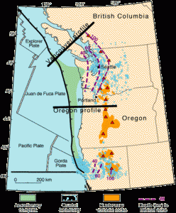
Scientists are just back from a monthlong research cruise in the Pacific Ocean off Washington state, where they were trying to find the stickiest point on a section of the Cascadia Subduction Zone, the huge undersea fault that breaks loose every few hundred years, generating a massive tsunami and earthquake.
Paul Johnson, a professor of geophysics at the University of Washington, was one of the principal investigators on the trip funded by the National Academy of Sciences. He says it will be some time before the data from deep-sea measurements of heat and gas emissions is fully analyzed, but preliminary indications are the strongest upheaval will be farther out to sea than previously thought, he said.
That is important because the farther out to sea that upheaval occurs, the bigger the tsunami, and the greater the damage on land from flooding, and the less damage on land from earthquake.

The subduction zone runs from Cape Mendocino, Calif., to Vancouver Island, B.C. It is the place where the rocky plate underneath the Pacific Ocean pushes under North America. It last gave way on Jan. 26, 1700, generating a magnitude 9 earthquake and a tsunami that washed away houses in Japan, said Brian Atwater, a geologist at the U.S. Geological Survey in Seattle who investigates geological evidence stretching back thousands of year of subduction zone quakes.
“Paul is trying to figure out how big the tsunami can be,” said Atwater, who was not part of the research team. “In deep water the tsunami generation can be especially effective. And Paul was out there in deep water.”
A study commissioned by the Oregon Legislature has estimated that more than 10,000 people could die and $32 billion in property could be damaged when the next one hits.
Scientists aboard the RV Atlantis were using the remotely operated submersible Jason II to take sensitive measurements of heat where the Continental Shelf gives way to the deep ocean. Their measurements were taken along a line from about 50 miles off Grays Harbor, Wash., to about 150 miles offshore. Robotic arms manipulated by the operators of Jason II stuck heat probes from 3 feet to 9 feet into the ocean bottom and spread out a blanket to measure surface heat. They also took measurements of gas emissions.
Working at depths up to 1.5 miles, they were looking for changes that would tell them where heat is building up because the fault is locked, like the break on a bicycle, Johnson said. Similar work has been done off Vancouver Island, but this was the first time it has been done off the U.S. Just where the stickiest points are along the 1,000-mile length of the fault are not known. The Cascadia is one of 10 subduction zones around the world being investigated.
The San Andreas fault in California slides side to side, but the Cascadia Subduction Zone moves up and down. That vertical jolt is like throwing a log in the water. It generates a big wave, which can send a 40-foot surge of water at the speed of a jetliner slamming into the coasts of Washington, Oregon and Northern California.
Scientists have done similar research off Vancouver Island, and Johnson hopes to do more off Oregon, perhaps by 2016, the soonest the RV Atlantis would be available for another cruise. Last summer, scientists did seismic research along the same area off Grays Harbor.
Because the research was financed by the National Academy of Sciences, the data will be publicly posted on the Internet in coming months for anyone to access and analyze, Johnson said.
Was this article valuable?
Here are more articles you may enjoy.

 Canceled FEMA Review Council Vote Leaves Flood Insurance Reforms in Limbo
  Berkshire Utility Presses Wildfire Appeal With Billions at Stake
  Tesla Sued Over Crash That Trapped, Killed Massachusetts Driver
  One out of 10 Cars Sold in Europe Is Now Made by a Chinese Brand