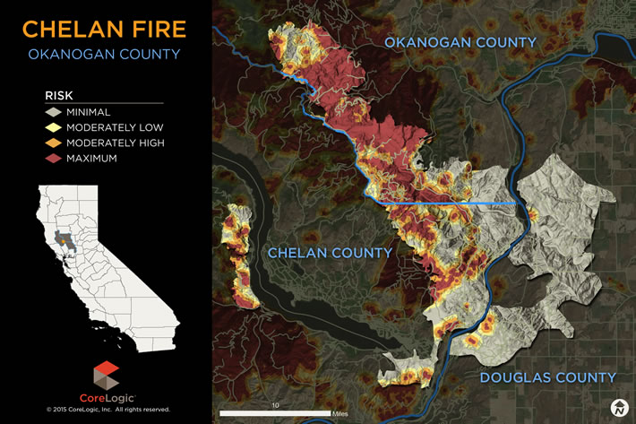
Close to 13,121 homes with a combined reconstruction cost of more than $3 billion are at some level of risk from the Chelan Wildfire, according to CoreLogic hazard risk analysis. The homes at risk are located in the following Washington zip codes:
98812
98813
98816
98831
98834
98843
98846
98858
Of that total, 634 homes, or 5 percent, with a total reconstruction cost of more than $198 million are at “Maximum Risk” or “Moderately High Risk” of damage.
Although the majority of homes, 12,156, or 93 percent, are at “Minimal Risk” of damage, wildfire can easily expand to adjacent properties and cause significant damage even if the property is not considered high risk in its own right.
Table 1 shows the risk levels for all of the homes in these eight zip codes based on the CoreLogic Wildfire Risk Score. This score indicates the level of susceptibility to wildfire damage and includes the risk associated with the property being located in close proximity to other high-risk properties or areas. The higher the score, the greater the risk of damage.
Table 1
| Wildfire Score (1-100) | Total Homes | Reconstruction Cost | |
| Minimal Risk | 1 to 50 | 12,156 | $3,365,335,401 |
| Moderately Low Risk | 51 to 60 | 331 | $91,954,769 |
| Moderately High Risk | 61 to 80 | 260 | $81,566,696 |
| Maximum Risk | 81 to 100 | 374 | $116,561,528 |
The reconstruction cost values represent estimates to rebuild the home, taking into account labor and materials, and are based on 100-percent or total destruction of the residential structure. Depending upon the size of the wildfire, there may be less than 100-percent damage to the residence, which would result in a lower realized reconstruction cost.
Source: CoreLogic
Was this article valuable?
Here are more articles you may enjoy.


 Elon Musk Alone Can’t Explain Tesla’s Owner Exodus
  Navigators Can’t Parse ‘Additional Insured’ Policy Wording in Georgia Explosion Case
  Tesla Sued Over Crash That Trapped, Killed Massachusetts Driver
  FM Using AI to Elevate Claims to Deliver More Than Just Cost Savings