Guy Carpenter & Company, Inc. has introduced i-aXs catastrophe mapping, an online tool that enables clients to assess specific properties at a potential risk of loss in areas impacted by catastrophes, specifically Hurricanes Katrina and Rita.
The web application uses pre- and post-event satellite images to review damages down to an individual location level. The site also features data layer controls that allow the user to view live radar images and precipitation bands of an active event and maximum sustained winds, storm surge and FEMA damage data on a post event basis. A limited, demonstration version of the tool is accessible from the homepage of Guy Carpenter’s Web site, www.guycarp.com.
Guy Carpenter accelerated the deployment of features of i-aXs, its proprietary exposure management platform in response to Katrina. The i-aXs platform, which is currently being tested with a number of clients, comprises a full suite of web-enabled tools that enable more efficient management of exposure data as well as data mining, analytics and real-time catastrophe information. i-aXs is expected to be available in limited release to clients in the United States later this year.
Was this article valuable?
Here are more articles you may enjoy.
 One out of 10 Cars Sold in Europe Is Now Made by a Chinese Brand
 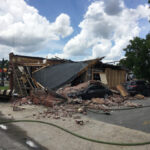 Navigators Can’t Parse ‘Additional Insured’ Policy Wording in Georgia Explosion Case
  Why 2026 Is The Tipping Point for The Evolving Role of AI in Law and Claims
  Founder of Auto Parts Maker Charged With Fraud That Wiped Out Billions
Want to stay up to date?
Get the latest insurance news
sent straight to your inbox.